NASA satellite data and models provide information for mapping fire risks nationwide, giving agencies tools for fire response, say scientists at the AGU Fall Meeting.

Soaring hundreds of kilometers above the Earth, a NASA satellite monitors soil moisture in the ground far below, probing drought conditions. Scientists at NASA Jet Propulsion Laboratory (JPL) analyzed these data and combined them with wildfire information from the U.S. Forest Service and land cover data from the U.S. Geological Survey. They used the results to assess fire risks, taking the first important step toward developing predictive maps for fires throughout the continental United States.
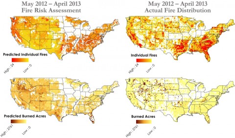
The JPL scientists, a team led by Nick Rousseau in NASA’sDEVELOP Applied Sciences Program, find that soil moisture data alone can approximately explain the distribution and extent of fires, from the Sierra Nevada to the western plains to the Florida wetlands. Their results determine how much the dryness of regions indicates fuel available for fires. They reported their findings on Wednesday at the American Geophysical Union Fall Meeting in San Francisco, Calif.
The Fire Next Time
Every year, wildfire outbreaks cause economic loss, property damage, and environmental degradation. Local, state, and federal agencies want to prepare for fire activity, and knowledge about particularly high risk areas would help them do so. If these new maps could be used to predict wildfire potential, then they would be an invaluable resource. “This shows how much overall area is likely to burn, which could be a useful tool when Congress allocates resources for fire management.”
“This shows how much overall area is likely to burn, which could be a useful tool when Congress allocates resources for fire management,” said Sparkle Malone, a research ecologist at Rocky Mountain Research Station in Fort Collins, Colo., who was not involved in the study.
Rousseau and his colleagues take advantage of NASA’sGravity Recovery and Climate Experiment (GRACE), which uses a pair of identical spacecraft flying in tandem 220 kilometers apart to precisely scan and measure tiny variations in the Earth’s gravitational field. These variations can be used to infer the regional movement of water over time, including evolving soil moisture as well as surface water and groundwater, explained Rousseau’s science adviser at JPL, John T. Reager.
Measuring Fire Risk
Partnering with the U.S. Forest Service, they used land cover data and fires observed over a 12-year period to train their model. In particular, they analyzed different types of land, including shrublands and deciduous and evergreen forests, which have different types of trees and vegetation that could fuel fires.

The scientists then modeled the relationship between soil moisture and fire risk and compared their predictions to satellite data from 2012 to 2013, at the beginning of the historic drought in the Southwest. They calculated the fire risk for every 125-mile (201-kilometer) pixel of the map, finding that dry areas are generally at high risk and usually coincide with more and larger fires over the time period. However, they came to the opposite conclusion for grasslands, where high moisture in the spring results in more flammable grass during the summer.
“This is the first chance anyone has had to quantify that,” said Reager. “And we’re doing this from space,” he added.
Other factors need to be included in the model in the future since in addition to soil moisture, winds, forest density, and lightning also contribute to wildfire outbreaks. When the GRACE 2 satellite launches in 2017, the researchers look forward to getting higher-resolution data as well. Rousseau, Reager, and their collaborators view their current work as a step toward a more complete map of fire risk in the United States, with which they could make detailed predictions for each fire season.
—Ramin Skibba, Freelance Writer
Source: https://eos.org/articles/assessing-u-s-fire-risks-using-soil-moisture-satellite-data


 EN
EN