

 VN
VNIntroduction
Oceanography, meteorology, and hydrology are three core scientific disciplines in Earth system science, focusing on the study of water and atmospheric systems from local to global scales. Oceanography investigates the oceans and the physical, chemical, and biological processes occurring in the marine environment. Meteorology focuses on the atmosphere and weather phenomena. Hydrology studies the water cycle, including surface water, groundwater, and their interactions. These three fields are closely interconnected, forming a complex interactive system.
In today’s digital age, the application of Artificial Intelligence (AI) has revolutionized the way we observe, analyze, and predict phenomena in these fields. AI, with its capability to process large datasets and recognize complex patterns, has become an indispensable tool in monitoring and studying these natural systems.
Historical Development of Observation Methods
Traditional Methods
Before the emergence of AI, research in oceanography, meteorology, and hydrology largely relied on traditional methods. These included radar observations, which have been used since the 1940s to monitor weather phenomena, sea movements, and rainfall. Weather radar systems can detect rainfall intensity, wind direction, and hazardous meteorological phenomena such as tornadoes. In addition, Earth observation satellites, launched since the 1960s, have provided global data on sea surface temperature, sea level height, chlorophyll concentration, atmospheric temperature, humidity, and precipitation. The Argo project, launched in 2000, consists of a network of thousands of autonomous floats measuring global sea temperature and salinity.
Furthermore, networks of observation stations, including meteorological, hydrological, and oceanographic stations, have been deployed in many locations to collect data on temperature, pressure, humidity, wind speed, river levels, streamflow, and other parameters. Sea level pressure gauges also play a crucial role in monitoring sea level variations over time, contributing to climate change research and tidal forecasting. Direct observation methods through field surveys using ships, meteorological aircraft, and in-situ instruments provide detailed data on the physical, chemical, and biological characteristics of the environment.
While traditional methods have made significant contributions to research in oceanography, meteorology, and hydrology, they have certain limitations. One major drawback is the limited temporal and spatial resolution, meaning data collection often occurs infrequently and over small areas, making it unsuitable for tracking rapidly changing phenomena. Moreover, integrating and processing multi-source data—such as satellite, radar, and station observations—is complex and time-consuming. Traditional models often rely on linear assumptions, which restrict their ability to predict complex nonlinear events such as El Niño, La Niña, or intense storms. Modeling multi-scale interactions is also challenging, as processes across different scales—from micro to global—are not yet fully connected. Additionally, the cost of field observations, including maintaining surveys and measurement stations, poses a significant barrier, requiring substantial financial and human resources.
AI Applications in Modern Meteorology, Oceanography, and Hydrology
1. AI in Meteorological Research
Artificial Intelligence has brought major advancements to numerical weather forecasting by effectively analyzing multidimensional meteorological data. Machine learning models can process petabytes of data from satellites, radars, and thousands of observation stations globally to provide more accurate forecasts. Convolutional Neural Networks (CNNs) are used to analyze satellite and radar imagery, while Recurrent Neural Networks (RNNs) are employed to process time series data of meteorological variables. AI systems can automatically detect and forecast extreme weather events such as tropical cyclones, tornadoes, and hailstorms using deep learning algorithms trained to recognize spiral cloud patterns typical of storms—leading to early warnings and 20–30% higher forecast accuracy compared to traditional methods.
Additionally, AI supports climate change research by analyzing complex climate patterns in historical datasets spanning centuries. These machine learning algorithms help identify hidden trends, detect tipping points in climate systems, and predict climate change impacts on specific regions.
2. AI in Oceanographic Research
In oceanography, the concept of the “Smart Ocean” refers to the integration of advanced AI technologies into marine observation and analysis. This system includes several components. In marine remote sensing, AI is used to analyze multispectral satellite data to detect and monitor phenomena such as El Niño, La Niña, ocean currents, and algal blooms. Machine learning algorithms can identify harmful algal blooms based on water color and spectral characteristics in satellite imagery.
Smart ocean sensor networks equipped with AI can automatically adjust measurement parameters based on environmental conditions and detect anomalies in water quality, temperature, and salinity—promptly reporting events such as tsunamis, red tides, or oil spills. Additionally, autonomous marine robots like AUVs (Autonomous Underwater Vehicles) and ASVs (Autonomous Surface Vehicles) equipped with AI can perform complex survey missions without human intervention, self-navigate, avoid obstacles, and collect data on seafloor topography, ecosystems, and water quality.
AI also plays a role in marine ecology by analyzing underwater acoustic data to track the behavior of marine animals—particularly identifying the calls of whales and dolphins to study population density and migration routes.
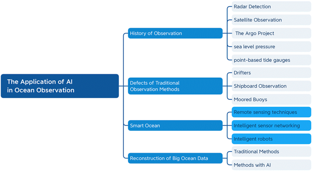
Illustration of AI applications in marine monitoring
3. AI in Hydrological Research
In water resource management, AI is applied to enhance the efficiency of water distribution and usage. AI models can predict water demand from communities and industries, optimizing water supply operations and detecting water quality issues early for timely treatment.
In disaster forecasting, AI systems analyze rainfall, soil moisture, and river levels to predict flood or drought risks—enabling early warnings and reducing loss of life and property. AI also supports groundwater research by analyzing geophysical data to determine the location and quality of aquifers. Machine learning algorithms can predict pollutant transport in groundwater, proposing appropriate measures to protect clean and sustainable water sources.
In interdisciplinary integration, AI plays a crucial role in developing integrated forecasting systems by merging data from multiple disciplines. For example, storm forecasting requires combining atmospheric pressure (meteorology), sea surface temperature (oceanography), and coastal topography (hydrology) to create more accurate predictions.
AI also aids in modeling the global water cycle, including ocean evaporation, atmospheric water vapor transport, and precipitation over river basins—helping better understand the large-scale movement of water. In ocean data research, traditional methods mainly rely on statistical interpolation and physical models to reconstruct large datasets, but these methods often lack the precision and detail needed to accurately reflect ocean conditions. AI offers more advanced, robust methods to analyze complex datasets and reconstruct ocean states more accurately and comprehensively.
AI significantly improves forecasting accuracy and efficiency in oceanography, meteorology, and hydrology, contributing to the protection of lives and property. Google’s DeepMind has developed an AI system called GraphCast that can forecast global weather up to 10 days in advance with superior accuracy compared to traditional models. This system uses Graph Neural Networks to model complex interactions in the Earth system, providing more precise climate and weather predictions.
IBM Weather’s early warning system uses AI to forecast hazardous weather events such as storms, floods, and droughts with an accuracy of 89%, significantly higher than traditional methods. This helps authorities and communities prepare in advance, minimizing damage.
Researchers at Stanford University have developed an AI algorithm capable of detecting and tracking pollutants like plastic waste, oil spills, and other contaminants on the ocean surface using satellite imagery. This system has been used to monitor the “Great Pacific Garbage Patch” and support marine conservation efforts—enabling authorities to identify polluted areas and respond promptly.
In the Netherlands, an AI system has been implemented to manage levees and control floods. It predicts river water levels based on meteorological and hydrological data and automatically adjusts floodgates to optimize flood prevention—helping reduce damage and ensure public safety.
AI is also used to forecast fishery resources: analyzing data on sea temperature, currents, and environmental factors to predict the distribution and migration of fish species. This helps fishermen optimize harvesting operations and assists policymakers in setting sustainable fishing quotas for long-term resource conservation.
Conclusion
The application of artificial intelligence in oceanography and hydrology has opened promising new opportunities. From improving observation and forecasting capabilities to reconstructing large-scale data, AI is transforming how we study and manage Earth’s water systems. However, to fully harness AI’s potential, substantial investment is needed in research, infrastructure development, and human resource training. At the same time, ensuring data quality and developing interpretable AI models are top priorities. In the future, we can expect increasingly intelligent and accurate AI systems that will play a crucial role in understanding and protecting our blue planet.
References
- Special issue “Applications of Artificial Intelligence in Ocean Modeling” , 3 July 2023
- Tao Song et al., (2023) A review of artificial intelligence in marine science, Frontiers in Earth Science, DOI:10.3389/feart.2023.1090185
- https://www.geeksforgeeks.org/artificial-intelligence/artificial-intelligence-in-oceanography/ ( 03 Jul, 2024)